Sunday, October 21, 2012

Walden Reservoir

Looking west towards the Zirkel Mountains. I rode here this spring on Duster.  That seems like a long time ago.

Looking east towards the Rawha Mountains


Bear in the truck

I rode Dakota.  He humped up his back and acted like he wanted to buck me off.  The wind was blowing pretty strong.  This could be the last ride of the year unless the weather gets nice again.  Zoe was with us too.  Didn't see anyone including hunters.  Didn't see any wildlife except for birds.

Sunday, September 23, 2012

Cliff Lake

Cliff Lake 


Bear & Zoe


Notes:  Rode Dakota, saw one hunter by his truck on FSR 996, parked at Bungy Park, didn't see any wildlife.  I would have taken pictures of the fall colors along FSR 700 and CR 11, but when I was pulling out of Bungy Park, I remembered that I had left the pump on at the water tank at home and couldn't stop to take any more pictures.

Friday, September 21, 2012

Blue Lake

This is the Blue Lake in the Rawah Wilderness on the east side of North Park.  The trailhead is accessed from CO Hwy. 14.


The pass (where the saddle is) leads over to the trail to Carey Lake.

Dakota and Bear
Notes:  weather - gorgeous, took Zoe & Bear, met two male hikers at the parking lot and later on the trail, no one was at the lake, didn't see any wildlife except for a covey of qual

Thursday, September 6, 2012

Willow Pass Trail

I was going to ride on the Bill Creek Trail which is off of the Stillwater Pass Road, but the road was closed with the metal gate swung across of it for logging. So instead I got the truck and trailer turned around and went back up CO Hwy. 125 to Willow Creek Pass at the border between Jackson and Grand counties.  This piece of the trail is part of the Continental Divide Trail.  When I got to the intersection with Trail 1226, I turned left or north.  Trail 1226 is used by motor bikes and is in great shape for horseback riding with all of the downed trees cleared and some form of a bridge over the wet places.


Dakota


This is the marker for Trail 1226 were it crosses CO Hwy. 125.
 Notes:  weather very nice, took Zoe & Bear, didn't see anyone or any wildlife


Friday, August 31, 2012

Camp Lake


Camp Lake is located on the eastern side of the Rawah Mountains.  To get to it you start from the West Branch Trailhead and follow the West Branch Trail for almost 3 miles until taking the right hand fork on the Camp Lake Trail.  This part of the trail is rocky and steep.  You climb for quite a while and then the trail comes to an abandoned irrigation ditch.  This part is pretty much level and smooth until it branches off again.  In another two miles or so still on a nice easy trail, you reach Camp Lake.  This was one of my favorite rides of the summer.  One reason for this is that there was only one downed tree that we (I was riding Dakota) had to go over.  


We did this ride on the Friday of Labor Day weekend and I should have known better.  I met multiple groups and single people on the trail especially on the West Branch portion.  It's hard to tell in this picture because I took it with my old camera, but there is a group of four guys on the shoreline right in the middle.


 Scree, or talus, is accumulation of broken rock fragments at the base of crags, mountain cliffs, or valley shoulders.  This scree field is horizontal which is odd, but this may not be natural but made by men and have something to do with the old ditch project in the area.


Notes:  the weather was gorgeous, only took Zoe because of the leash law, map had the distance at 7.7 miles one way, but it didn't seem that far

Wednesday, August 22, 2012

Pictures from the Ranch

I usually don't take that many pictures around our ranch because I see it every day.  But my nephew, Joel, was out visiting this summer from Ohio and before he went home I took some pictures of him.  

The Cabin - Joel stayed here and Scott's family stays here when they are visiting.

The Shop

Joel on our four-wheeler

Copper

Copper and Dakota with Mickey my little miniature horse in the background

Moe, my small mule

Joel sitting on the round corral fence that we built this summer

The round corral can be used to break or train horses.

Dakota and Scott

Zoe, Joel, and Bear

Our dump truck, John Deere 2750 tractor, and truck and trailer

The garage and back of the house

Herman (named after Herman Munster) a 1964 GMC Jimmy
I

Monday, August 20, 2012

Bear Lake

This is my second attempt to go to Bear Lake.  On the first try on July 2, 2010, I was riding Duster with Bear and Zoe with me.  We got to within a half mile of the turnoff down to Bear Lake and there was still too much snow and the trail became impassable.

On this trip, I actually saw a bear!  It was the first one I have ever seen in the wild other than from a vehicle.  Dakota saw or smelled him first and then I looked to see what Dakota was looking at and saw the bear peeking out from behind a bush.  He was small and looked young and was different shades of light brown.  He ran away immediately.
The trailhead for the Grizzly-Helena Trail that leads to the Bear Lake Trail


There is an old miners cabin and a mine dug into the side of the rock mountains.  I thought I had a picture of the cabin, so I didn't take another one.  I don't know if the miner died there or just gave up and left, but it has always felt like a spooky place to me.


I don't know what kind of bird made this nest, but I thought it was cute.

The trail continues past the turnoff down to Bear Lake up to Ute Pass.  


Bear Lake

It's not a very big lake, but pretty cute.  I almost turned back because I thought I had gone far enough from the turnoff and the trail was getting very difficult with downed trees blocking it.  Then I heard some running water and kept going and we were only a short distance from the lake.  I'm so glad that I kept going because that would have meant a third attempt at some later date and I would have kicked myself when I found out we were that close.
Zoe

NOTES:  Rode Dakota, went with Bear & Zoe, saw two older male hikers together, weather cool with a little sprinkles, but then sun, parked along the road in front of the trailhead and was able to turn around in the Lake Katherine/Bighorn parking area because there were no vehicles parked there

Tuesday, August 14, 2012

Seven Lakes

The little burg of Pearl, elevation 8405, on the way to the  Beaver Creek Trailhead.

Pearl used to be a thriving town with a copper smelter.  Now it is a collection of summer homes and a few ranches.


The Beaver Creek Trailhead.  It took me an hour to drive here.
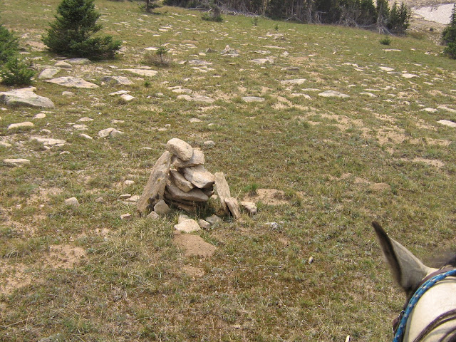
This is a cairn which is a heap of stones piled up as a landmark.  Parts of the Buffalo Ridge Trail that goes to Seven Lakes were very hard to follow.
An alpine meadow

Dakota at our lunch spot
Looking south towards the Sawtooth Range


At the intersection of the Buffalo Ridge Trail and the Big Creek Trail

Seven Lakes - not sure if there are actually seven lakes, but there is a collection of small alpine lakes


NOTES: These pictures were taken with my old Canon Powershot.  Zoe and Bear went on the ride too.  Easy to turn around and plenty of parking at the trailhead.  The weather was very pleasant.  Two of Red Feather's truck and trailers were there, but never saw anyone on the trail.  
The Buffalo Ridge Trail from the intersection with the Beaver Creek trail was in very bad shape with a lot of downed timber.